With spring upon us, now is the time to think about getting your environmental consultant back out in the field. This is our favorite time of year for wetland delineation— the multi-flora rose is still in check, it’s not too hot out, and the ticks are still sleepy (just kidding, ticks never sleep). Our comfort aside, Spring really is the time to capture critical survey windows for many threatened and endangered species.
Let’s start by breaking down the basics:
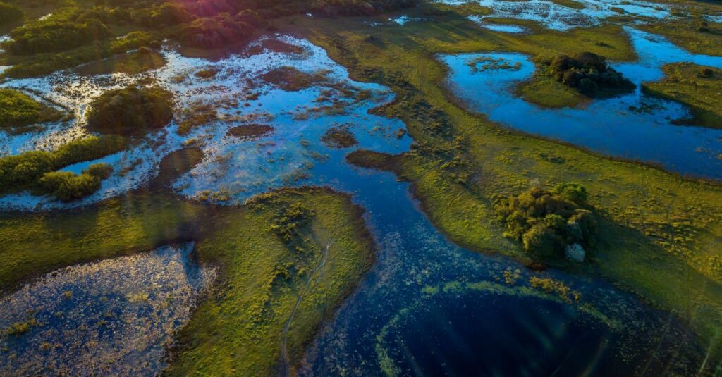
What is a wetland?
A wetland represents a distinctive ecosystem characterized by permanent or seasonal water saturation, encompassing environments like swamps, marshes, bogs, vernal ponds, and related areas. They provide water quality improvement, flood protection, shoreline erosion control, food for humans and animals, and critical habitat for thousands of species of aquatic and terrestrial plants, aquatic organisms, and wildlife.
What is wetland delineation?
Wetland delineation involves conducting fieldwork to identify and establish the boundary separating upland areas from wetlands on a property. This on-site investigation adheres to guidelines set forth by the United States Army Corps of Engineers (USACE) and is necessary for obtaining permits.
Why is wetland delineation important?
Wetland delineations play a critical role in offering insights into the location, size, and features of wetlands within a specific area. By pinpointing these areas, they facilitate informed decision-making regarding land use by identifying regions subject to regulatory protection under the Clean Water Act.
Wetland delineation is essential for:
- Project Initiation: Wetland identification and delineations are a pivotal stage in the design process, serving in the initial phase of reducing or eliminating impacts to wetlands. By accurately locating wetland boundaries within a project area, the project can be designed in a more environmentally sensitive way, thereby decreasing the potential of inadvertently damaging wetland ecosystems.
- Water Quality: Conducting wetland delineations plays a crucial role in safeguarding water quality. By identifying wetlands, engineering controls, such as silt fencing, can be established to help protect wetlands from potential sources of both direct and indirect point source pollution.
- Project Design: Wetland hydrology and soil conditions require unique engineering design and control specific to these areas to ensure the safety and efficiency of any project including matting, excavation depths, and trench shoring.
- Habitat Protection: A variety of threatened and endangered species utilize wetlands as core habitat. Defining wetland boundaries allows for the identification of these habitats as they relate to a proposed project and allows for the planning of avoidance measures and engineering controls that protect these key species.
- Restoration: Knowing the boundaries of a wetland system before construction allows for proper restoration of the system following construction.
Wetlands are present on every continent except Antarctica, showcasing a diverse array of shapes, sizes, and hydrological, ecological, and geological conditions. AEDES’ environmental team are experts in wetland identification and delineations all over the United States, providing a wide range of environmental services, including regulatory compliance and permitting, functional assessments of wetlands and streams, water resource studies, habitat assessments, resource management, and restoration and monitoring.
Why is Spring a critical time to get out in the field?
During the winter when we can’t see what plants are there, it makes the delineation a lot harder. Certain plants bloom at certain times and spring is certainly a good time for some. As for wetlands, when plants start to grow that’s when we are better able to identify wetlands.
The start of the growing season is an ideal time to identify dominant plant species in a wetland without the site becoming overgrown and hard to navigate. More importantly, it allows time to identify the necessity for threatened/endangered species surveys while still meeting upcoming survey windows.
What is the most efficient way to identify rare, threatened, and endangered plants?
Identifying rare, threatened, and endangered plant species is a pivotal task within the permitting process. The most efficient way to accomplish this critical task involves a multi-pronged approach. First, consulting with state and federal agencies and reviewing existing databases and conservation lists provided by local and national environmental agencies can offer an initial overview of known species in a project area. Secondly, conducting site visits to determine existing habitat types can guide targeted field surveys. Finally, engaging experienced botanists and biologists to conduct these surveys ensures accurate species identification and evaluation. This combined strategy enables environmental professionals to precisely locate and protect sensitive plant species during project planning and execution, ensuring compliance with environmental regulations and the preservation of our natural heritage.
A significant body of past research focused almost exclusively on using leaves for plant discrimination. This preference stems from methodological conveniences rather than botanical significance. In reality, identifying plants in their vegetative state without flowers is a complex task. However, leaves present numerous advantages that make them ideal for computer vision analysis. They are generally available year-round, enabling continuous study. Their planar geometry simplifies collection, preservation, and imaging processes, making data acquisition more straightforward. This has led to leaves being the primary focus for developing automated plant identification methods for environmental assessments. Typically, the focus is on broad leaves, with needles often being overlooked or treated as a separate category.
Survey Deadlines to consider:
A spring plant that is soon to be flowering that you should keep an eye out for is Trilliums. Easily identifiable by their 3 flower petals and irregular petal arrangement, some Trilliums can be uncommon in the wild with the Nodding Trillium, Declined Trillium, and Snow Trillium all proposed threatened by the Pennsylvania DCNR, and the Painted Trillium a state endangered in the state of Ohio.
Furthermore, several upcoming survey deadlines necessitate prompt attention:
- Bog Turtle (federally threatened) Phase II species surveys: April 15 to June 15. (Note: Phase 1 habitat surveys can be conducted any time of year, provided there is no snow).
- Small-Whorled Pogonia (federally threatened): May to June
- Northeastern Bulrush (federally endangered): June to July
- Mussel surveys in Ohio: May 1 to October 1
It’s also important to incorporate construction moratoriums into your schedule. Tree clearing restrictions for most bat species are typically between March 31 and October 1 (may vary slightly depending on the species or the region your project is located). In-stream restrictions vary greatly based on the classification of the stream and the type of fish that are present. These are just some of the potential issues your project might face. Under certain circumstances or conditions, a waiver or variance can be issued. It can be challenging to navigate what can sometimes be small windows to work in, but we’re here to help guide you through that process!